

Weather Highlights
Flash Flooding, Heat Dome, and Active Tropics

Weather Highlights for the Upcoming Week
A life-threatening and disastrous flash flooding event will unfold across southern California and southern & central Nevada on Sunday-Monday.
The flooding risk will expand into Idaho, eastern Oregon, southeast Washington state, and western Montana late Sunday-Tuesday.
An expansive ridge will build and become centered over the central Mississippi Valley and Midwest/Corn Belt, resulting in very dry conditions and excessive heat across most of the eastern two-thirds of the U.S.
Southern Texas could be the exception in regards to rainfall, where tropical activity could develop in the Gulf of Mexico and move westward into lower parts of the state on Tuesday.
New England could be the exception in regards to temperature, where troughing will nose into the region most days, allowing for average to below average temperatures.
A backdoor cold front may manage to filter in some of that cooler air into the Mid-Atlantic and even into parts of the Carolinas around mid-week. The remainder of the Southeast will bake.
Forecast Discussion
I’ve already expressed my concern for the potentially historic flooding event that’ll unfold across parts of southern California and southern Nevada from Sunday into Monday. It’s important to understand that Hurricane Hilary isn’t the only piece to this puzzle. An mid/upper-level low/trough currently sits along the California coastline, which will 1) further enhance rainfall development/intensity and aid in fetching moisture from the deep tropics. Add in the burn scars, soil type, topography, etc., and you have the recipe for a disastrous flooding event. Some areas will get 1-2+ years worth of rainfall from this event alone. Even if Hilary were expected to make a hard turn west before entering California (which isn’t going to happen), we’d still be forecasting a relatively high-end flooding event due to the overall synoptic pattern (the different pieces of the puzzle coming together).

Figure 1: Flood Risk Map for the Southwest
As Hilary comes northward into the southwestern U.S., it’s interaction with the feature off the California coast will promote the amplification and strengthening of a strong ridge downstream. Excessive heat warnings already extend from Texas/Louisiana to Minnesota and more warnings and advisories will likely be added. Many of the areas outside of the South and coastal areas have experienced a rather mild summer, which’ll make this heatwave even more severe from an acclimation standpoint. Parts of the mid-Mississippi Valley and Corn Belt (not Iowa though) have received around 150-400% of their average rainfall over the last 30 days. Thus, humidity levels will especially be oppressive, aided by evapotranspiration from the corn fields. Fortunately, the ridge will mostly break down by next weekend

Figure 2: Current Advisories and Warnings
It’s not hard to spot the ridge in the upcoming 7-day rainfall forecast. Strong ridging (high pressure) promotes sinking motion in the atmosphere, reducing rain chances and clouds. The periphery of the ridge is where all of the storminess occurs. Given the ridge’s central position, southern Texas could face impacts from a tropical disturbance that’ll trek westward underneath the ridge this weekend and early next week. This feature could manage to become better organized into a depression or storm before bringing rainfall to lower Texas on Tuesday.
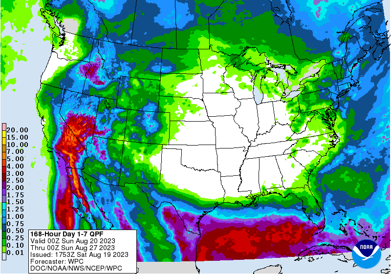
Figure 3: WPC 7-day Rainfall Forecast
New England will escape this week’s heatwave and will have several shortwaves pass through or skirt the region, favoring rather persistent troughing. Surface high pressure will build into the region around mid-week, which will usher in a backdown cold front into the Mid-Atlantic and potentially reach part of the Carolinas.
Elsewhere in the South, the heat will be excessive. Dry conditions will prevail this week, except across lower Florida (though rainfall will still run below-average there too). The heat will stay around for at least a week and then persist beyond the next 7 days from the Mid-South/Texas westward. Cooler air may attempt to extend as far south as the northern Gulf coast states in the following week, but we’ll discuss that more in the next newsletter.
-Matthew