

Weather Highlights
What kind of weather to expect early to mid-August

Weather Highlights for Early to Mid-August
A strong, persistent ridge will subdue the typical monsoonal flow across the Southwest and continue bringing well-above average temperatures.
Numerous days of storms will develop and trek across the northern/central Plains, lower Midwest/mid-Mississippi Valley, Tennessee Valley, and upper Southeast states.
Areas near/along the Gulf coast and across Florida will experience above average temperatures and generally average to below average rainfall.
Texas and the mid-South will continue to swelter, with temperatures even higher than what the typical August brings.
From the Inter-mountain West to the central and northern Great Plains, temperatures will run below average for an extended period.
The Mid-Atlantic and New England states will have more volatility in temperatures, going back-and-forth between well-above and below climatology.
The Pacific Northwest will periodically receive periods of storminess earlier this month, with a major upward trend in temperatures between now and mid-month.
Forecast Discussion
A stubborn ridge centered across the Southwest resulted in the region having its hottest July in the modern record. The longevity of the heat wave explains why such a record was breached, even though some of the all-time hottest temperature records weren’t broken. The unfortunate news is that the ridge will likely persist through at least mid-August, resulting in a lackluster monsoon season and strengthening drought.
Across the heart of the U.S., July has generally been mild. If you take June into account, a large part of the Southeast, Ohio Valley, and Mid-Atlantic have also experienced a rather mild summer. This pattern will continue into August for some of these regions. Persistent, long-wave troughing will introduce an early and extended taste of fall across the Inter-mountain West, central/northern Plains, Midwest, Great Lakes region, Ohio Valley, and at times, inland New England.
Unfortunately, the Southeast and up the eastern seaboard will stay mostly hot (above average temperatures). Some of the cold fronts may push into the Tennessee Valley and Mid-Atlantic region, but most will stall out before making it through the Southeast.
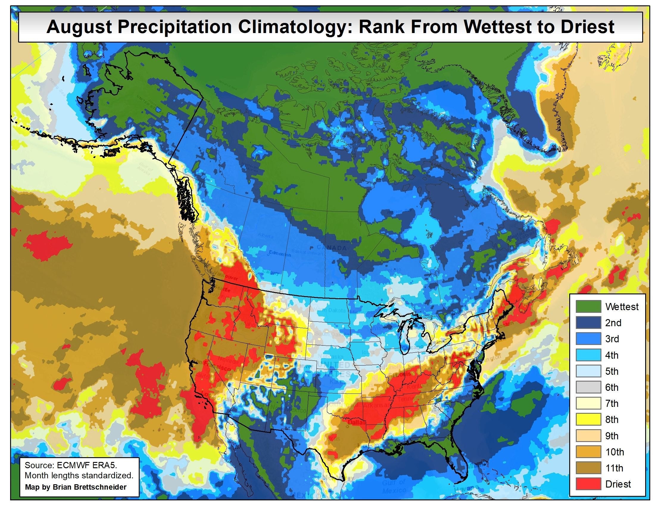
August is usually the driest month of the year across the Mid-South, mid-Mississippi Valley, lower Ohio Valley, and Tennessee. However, in early to mid-August this year, the mid-Mississippi Valley, Tennessee, and upper Southeast will find itself positioned between the ridge out west and the trough. Not only will this result in a severe weather risk, flash flooding will also be a concern with this pattern. The flooding risk this week could actually be a big deal. Don’t take this lightly.
I’ve attached a couple images below to emphasize my point. The first image shows in green where rainfall could be anomalously high over the next 7 days. In general, model guidance agrees a similar pattern could persist beyond 7-days.

The second image shows where August usually ranks in terms of precipitation amounts (red=August is usually the driest month; green=August is usually the wettest month). If you compare the two graphics, you can see that the mentioned regions will experience at least a very wet start to August, a month that tends to be driest.
That’s all I have for you for now. We’ll keep you updated on the latest, as always.
-Matthew Holliday