

Weather Highlights
A lot to discuss: Hurricane Idalia, heat, floods, and more.

Weather Highlights through this Weekend
Unsettled weather across the Pacific Northwest, caused by two shortwaves
Cooling trend across the western third of the U.S.
Substantial increase in monsoonal activity across Arizona, Utah, and southeast Nevada late week into weekend
Worsening Texas drought
Cool and dry air to funnel into Midwest, Ohio Valley, Mississippi Valley, and Tennessee Valley by mid-week
Mild and unsettled weather expected across New England Tuesday into Wednesday but cooler and drier afterward
Stormy pattern Tuesday into Wednesday across parts of Southeast (right before Idalia’s impacts arrive)
Hurricane Idalia to bring devastating impacts to Florida (flooding, storm surge, winds); landfall anticipated early Wednesday morning
Idalia impacts expected across southeast Georgia and the Carolinas Wednesday-Thursday timeframe
Heat to re-build east of the Rockies this weekend into next week

Scammers and Spammers Hate Aura - and That's a Good Thing for You
Are you tired of unwanted emails, texts, and calls from scammers and spammers? Aura uses cutting-edge AI technology to scan the internet to identify where your personal information is exposed and being sold. With Aura, you can take control of your online privacy and secure your personal information. Reduce robocalls and keep your information safe from identity thieves. Try Aura free for 2 weeks and see if your information has been compromised.
(It helps Firsthand Weather make a few extra bucks when you sign up for the trial. 😃 -Matthew)
Forecast Discussion
Let’s work our way from west to east.
Around mid-week, a ridge will build and amplify into the Gulf of Alaska, which will set off a chain reaction downstream across the U.S.
As the Gulf of Alaskan ridge amplifies, a shortwave will dig southeastward into the Pacific Northwest and close off into a mid-level low. After bringing more rainfall to western/central Washington state and Oregon later in the week, the low will stall out for a few days across Oregon/California. This pattern will cause a major uptick in the monsoon, with a flood risk, across Arizona, Utah, and southeast Nevada by late week/early weekend. Temperatures will trend downward into well-below average territory from the West coast around mid-week to everywhere along and west of the Rockies by the weekend.
A shortwave will dip down across the Upper Midwest and Great Lakes region late Monday into Tuesday and carve out a trough across the northeastern quadrant of the U.S. by Wednesday. The strength and timing of this trough will actually influence how soon Hurricane Idalia makes a northeastward turn toward Florida and partially determine its landfall location. An associated cold front will bring another infiltration off cooler, dry air into the Ohio Valley, Tennessee Valley, and Mid-South (relatively-speaking) around mid-week. Unfortunately, Texas didn’t and won’t get much in the way of rainfall; thus, we anticipate drought worsening for most of the state.
The Mid-Atlantic and New England will initially be on the warm side of the trough from Tuesday into early Wednesday, but the cooler air will filter into most of the region mid-week. A round or two of rain/storms will move across much of the region between now and Wednesday before the cold front passes through.
A stalled frontal boundary is currently draped from lower Louisiana/Mississippi to the Mid-Atlantic. This front, along with the incoming trough to the north, has helped enhance rain and storm chances (along with a flash flooding risk) across parts of the Southeast and lower Mid-Atlantic. These heightened storm chances will continue into Tuesday and even Wednesday. Idalia’s rain bands will begin bringing rainfall as early as Tuesday to Florida. On Wednesday/Thursday, widespread, heavy rainfall will extend across Florida and expand across the southern half of Georgia and at least the eastern half of the Carolinas. Our upcoming forecast discussions on Idalia are a bit too lengthy for this newsletter, but keep checking in with us for updated forecasts on social media and the website.
Unfortunately, a ridge will begin building back across the central U.S. by late week and cause a major warming trend over the weekend. This ridge will extend eastward from the Great Plains, Midwest, Mississippi Valley and Mid-South by this weekend. The heat will expand across most locations east of the Rockies by early next week. No matter how tempted you are to put away the short-sleeves, don’t. The heat will return.

Figure 1: Projected high temperatures and departures from average this upcoming Wednesday
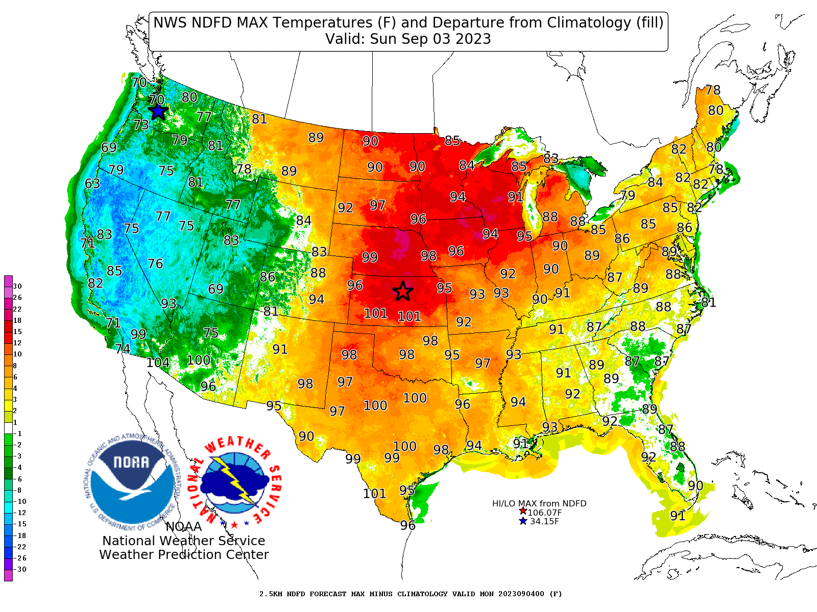
Figure 2: Projected high temperatures and departures from average this upcoming Wednesday

Figure 3: Projected rainfall totals from now through mid-weekend
Awesome, thanks for the update!
I love Firsthand Weather’s detailed and informative explanations of what will happen and why. Thank you!!