Weather Highlights for Monday (Nov. 18) through Sunday (Nov. 24, 2024)
We're definitely moving toward the active winter months.
Happy Sunday evening, everyone! We have a lot of weather to track this week, so we apologize for the newsletter being longer than usual. We organized it in such a way that you can skip around and skim if that’s your preference. And as always, we’re open to your feedback to improve the quality of this product. With the approaching winter months, we’ll generally send out this newsletter once a week, usually on Sundays.
Snow/Ice Forecast Highlights & Discussion
Northern Plains & Upper Midwest snow. Timeframe: Tuesday-Wednesday
Heavy snow across the Cascades, Sierra Nevadas, & upper and middle Rockies. Timeframe: Now through next 10+ days
Lower and middle Appalachian snow accumulations. Timeframe: Thursday-Friday
Highlight 1 discussion: Two storm systems, one trekking across the Great Lakes and the other moving into the Pacific Northwest, will merge (phase). In response, a surface low will develop and strengthen. Precipitation will develop on the backend of the intensifying surface low, eventually transitioning from rain to moderate/heavy snow across much of North Dakota and northern parts of South Dakota. As the low eastward, the Upper Midwest could see some snow, too.
Highlight 2 discussion: An active weather pattern will bring rounds of heavy snow to the mountains of the West. Snow levels will fluctuate leading to a tricky forecast with some communities seeing rain and snow at times. Snow levels fall behind a cold front on Monday from 5,000 feet to around 2,000 feet. Up to a foot of snow is possible for the Cascade range from Washington down to northern California, impacting the mountain passes. The Intermountain West northern mountains, including the northern U.S. Rockies, will see over half a foot of blowing snow on Monday.
A stronger storm system arrives from mid through late week, mainly impacting the Pacific Northwest from northern California, up through Oregon, and Washington. This system will be warmer [see the section below detailing the Atmospheric River] so snow levels increase to above 5,000 feet from mid to late week, meaning locations that see snow Monday will see rain come the end of the week. Several feet of snow are possible for the Cascade Range above 5,500 feet with the heaviest snow above 7,000 feet. The remnants of this system and subtropical moisture move into the northern U.S. Rockies and Intermountain West mountains over the weekend but moisture will be minimal, but half a foot to a foot of snow can still be expected. Another storm system, although weaker, arrives late next weekend into the following week delivering more snow to the Pacific and Inland Northwest.
Highlight 3 discussion: As two systems phase over the Plains earlier in the week, a blocking ridge over the Hudson Bay region will force the merged system southeastward into the eastern U.S. The closed, mid-level low will dig as far south as the Mid-Atlantic, allowing strong northwesterly flow to develop over the Appalachians.
Hefty snowfall accumulations are increasingly likely across the Allegheny mountains (6-12 inches). Accumulations could occur as far south as the Tennessee/North Carolina border, with a few flakes potentially flying in the northeast Georgia mountains.
Rain/Severe Weather Highlights & Discussion
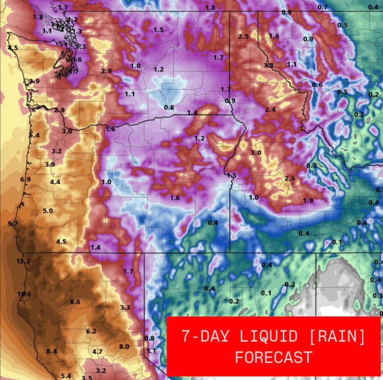
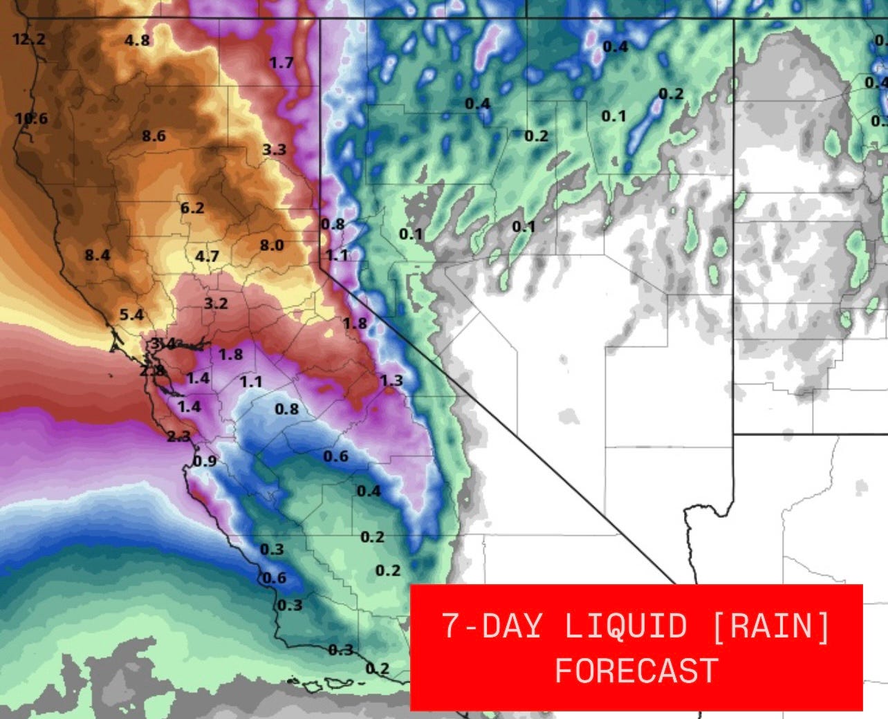
Numerous rounds of heavy precipitation across the Pacific Northwest and northern California
Potent storm system to bring rain/severe weather to Plains. Timeframe: Now to Monday
Round of rain/storms across Mid-South & Southeast, with activity extending into Ohio Valley. Timeframe: Mainly Tuesday but starting Monday to west
Storm system to move into New England and Mid-Atlantic. Timeframe: Mid to late week
Highlight 1 discussion: An active, high-impact weather pattern is evolving this week for the Pacific Northwest [PNW], continuing at times over the next 10 or so days. This weather pattern will feature a hyper-active storm track that will deliver heavy lowland rain [especially to coastal areas and the western foothills on the west side of the Cascade range], heavy mountain snow [at higher elevations as snow levels increase due to milder air associated with an atmospheric river], strong wind gusts, and even some lowland flooding near coastal areas via storm surge.
While the precipitation will be beneficial [especially the snow for the Cascades], the potential of a moderate to strong atmospheric river [AR] could lead to too much rain causing some areas of flooding [favoring areas along the southern Washington coast, coastal Oregon, the northern California coast -possibly bleeding into central California- and the western foothill communities].
Before the AR event, a storm system is impacting the PNW this evening with falling snow levels as a strong cold front moves through. Snow levels will fall to around 2,000 feet later this evening, impacting most passes. There's a Winter Storm Warning in effect until Monday from Washington south into northern California where up to a foot of snow is possible along with localized higher amounts. The snow will also be associated with strong winds leading to low visibility and difficult travel. Once this storm passes, the next one evolves over the northeastern Pacific by midweek.
This storm system [and associated AR] will start to evolve Tuesday into midweek, with impacts continuing through the end of the upcoming week as a strong low pressure forms off the coast of the PNW. This intensifying area of low pressure will tap into a rich fetch of subtropical moisture from more equatorial parts of the Pacific Ocean, slinging it into coastal parts of Oregon and northern California with some of the moisture also moving into Washington. This AR has the potential to be on the strong side meaning it's more than beneficial leading to the potential of damaging impacts such as river flooding and land/mudslides.
The exact landfall is uncertain, but it looks to make landfall somewhere along the northern California coast [possibly extending into central California] and southern coastal Oregon. Heavy coastal rain [and in the western foothills], strong, gusty winds along with storm surge is forecast from Washington to northern California along with heavy snow in the Cascades extending into parts of the Sierra Nevada range. Coastal areas can expect half a foot of rain, potentially nearing a foot of rain in the western foothill communities on the west side of the Cascade range, and a few feet of snow in the mountains. Snow level will increase from 2,000 feet early this week to over 7,500 feet in northern California, over 6,500 feet in Oregon and over 5,500 feet in Washington from mid to late this week because of the warmer air associated with the AR.
Wind gusts along the coast of 40 - 65 mph are expected along with a 2 - 4-foot storm surge in some locations and near inlets. Remnant moisture from the AR and storm system will move into the Inland Northwest and northern parts of the Interior West over the weekend. Moisture will be minimal in comparison to areas west of the Cascade range but appreciable snow totals are forecast for the northern U.S. Rockies.
The potential for another weaker AR is possible with another storm system late this upcoming weekend into the early parts of the following week for parts of the PNW.
Highlight 2 discussion: A strong, mid-level will continue digging southeastward into Baja California and northern Mexico today, establishing deep, southwesterly flow and lift across the lower Plains. Moderate to heavy rainfall will continue filling in across eastern New Mexico, much of Texas (especially the western half), and Oklahoma/Kansas tonight into Monday. In addition to several inches of rainfall and the risk of flash flooding, a wind and tornado risk will develop across parts of Oklahoma and northern Texas on Monday.
Highlight 3 discussion: As southern and northern stream systems phase over the Plains, a surface low-pressure system will develop and strengthen as it treks northeastward, driving a cold front southeastward. Ahead of the front, deep, southwesterly flow will favor the development of moderate to heavy rainfall (with storms also possible) across the Mid-South and Southeast. An embedded shortwave pulse will focus the heaviest rainfall totals closer to the Gulf Coast from Louisiana to the Florida panhandle, where flooding will be possible. A segment of rain/storms will also develop and move across the Tennessee and Ohio River Valleys.
Highlight 4 discussion: The strengthening storm system largely responsible for the upcoming eastern cold air intrusion (discussed below) will bring a multi-day period of rain and chilly weather conditions across much of New England. Also, as cold air wraps around behind the system, rain will potentially transition to snow later in the week in the mountainous regions of New England. However, the majority of the region will get cold rain. Rainfall totals from mid to late week are expected to reach a widespread 1-2+ inches across much of New England and northern Mid-Altantic.
Temperature Highlights and Forecast Discussion
Modest cold air intrusion across the eastern U.S. Timeframe: Later half of the week into the weekend
Highlight 1 discussion: A major, albeit somewhat brief, change in the overall pattern will begin to evolve starting early in the week. Temperatures will begin the week well above average for essentially the eastern two-thirds of the nation early into mid-week, while the western third of the U.S. remains cold. But as a strengthening storm system over the Plains and Midwest gets trapped underneath a Hudson Bay ridge, a large-scale trough will develop and dig across the eastern U.S. Across the West, ridging will build ahead of a strengthening trough over the northeastern Pacific.
When comparing the projected high temperatures for this Monday and Friday, it’s easy to spot the contrast. However, it won’t have much staying power. A tendency for ridging (with above-average temperatures) to build across the eastern U.S. (especially the Southeast) seems to persist through early December. So appreciate these bouts of colder weather while they last.


Who will be able to report on weather if we defund NOA?