

Weather Highlights (Mid to Late August)
An omega block to bring a plethora of weather conditions to the U.S. next week

Forecast Discussion for Next Week
An omega block pattern will establish itself across the United States in the coming days. These patterns resemble the capital Greek letter Ω, which essentially is an amplified ridge sandwiched between two troughs. This pattern generally brings cooler weather to regions under the troughs and hot/dry conditions for regions under the ridge. Stormy conditions can occur along the periphery of the ridge and just downstream of the trough axes.
The ridge will continue building over west Texas/Oklahoma and Southwest this weekend. As a closed low digs southeastward and approaches the Pacific Northwest coast, the ridge will amplify/build into the eastern Rockies, northwestern Plains, and Alberta, Saskatchewan, & Manitoba tomorrow into next week. On the other side of the strengthening ridge, a couple of shortwaves/closed lows will drop down into New England, carving out a trough over the eastern U.S. As a result, an early-week cold front will sweep across the eastern U.S., eventually pushing through the Gulf coast and northern Florida peninsula by Tuesday before stalling out across Florida.
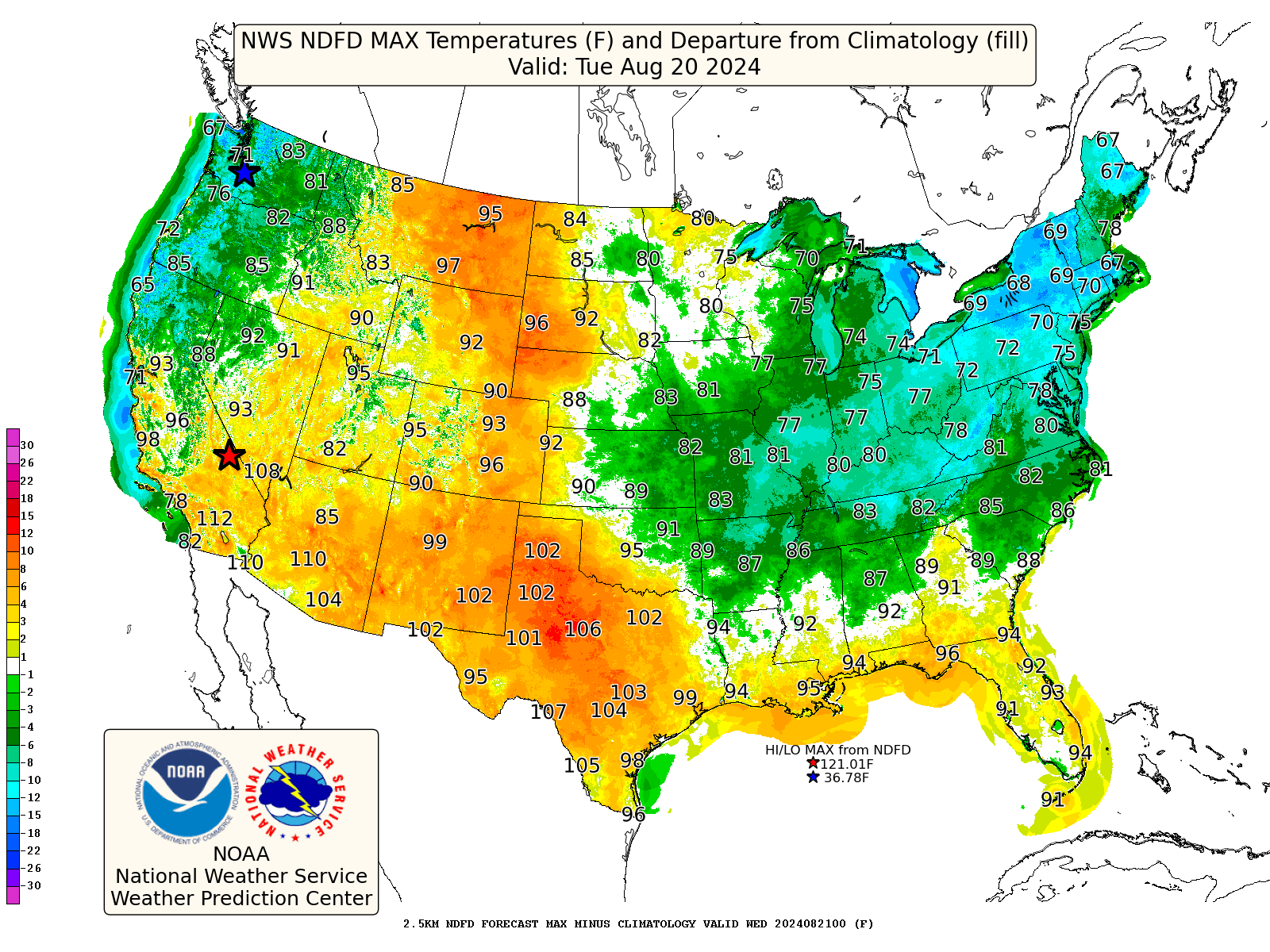
I’ve included the forecasted high temperatures for this Tuesday (the shading shows where temperatures will be above/below average). Notice the below average temperatures across the eastern U.S. and along/near the western U.S. coast and very hot weather in between. Thank you, Omega block!
Weather Highlights for Next Week
Flood risk for large swath of Utah, northern Arizona, western Colorado, and southwest Wyoming
Locations across the eastern Great Basin and parts of the Colorado basin will continue to have a flash flooding risk over the next several days, possibly longer. The region will be positioned to the east of an amplifying trough and along the western periphery of a strengthening ridge, thus making the area favorable for daily storm activity. Atmospheric profiles will remain unusually moist, due to persistent southwesterly flow, in a region that has already received 200-400% + of their typical rainfall over the last two weeks.
Near-record strong ridge across west Texas and Southwest, resulting in long-duration heat wave; heat to extend into lee of Rockies and western Plains
A strong ridge will build across the Southwest and west Texas, and it’s not going to budge, not much anyway. As a result, temperatures will be well above average across these regions, pushing well into the 100s across west Texas into eastern parts of New Mexico. Highs well into 90s to even near 100 will exist across the lee of the Rockies next week. Even eastern Montana will have some high 90s!
A much cooler Ohio Valley, Mid-Atlantic, and New England
A stormy weekend will persist into Monday across the Mid-Atlantic and New England, but then the weather will do a complete 180 by Tuesday. A cold front will push through the entire region by Monday. Cooler and drier air will further be reinforced by a stronger, second closed low that’ll drop into New England Tuesday/Wednesday. Conditions will be dry, and especially for New England, very fall-like. Thanks to the Omega block pattern, the cooler temperatures will stick around for a few days. But it is only mid-August, so temperatures will be on the uptrend by next weekend.
Cold front will even make it to Gulf Coast and northern Florida peninsula next week
Parts of the Southeast, Mid-South, and all of the Tennessee Valley will get a taste of fall next week, sorta. A cold front will sweep through on Monday and a cooler and drier airmass will be further reinforced by a closed low dropping into New England early in the week. This will knock temperatures down quite a bit. It will be noticeable cooler in the Mid-South where there’s currently a large swath of excessive heat warnings. Temperatures will still probably push into the 90s near the Gulf coast, but be in the 80s to around 90 elsewhere. Morning temperatures might have a chill to them for a few days. Coupled with much lower humidity, that’s a win in my book for August.
Some Brief Long-range Discussion
I expect that the strong ridge across the Southwest and part of the Southern Plains will stick around for 7+ days. Most medium and long-range guidance depicts a strong ridge remaining over these same regions but potentially extending eastward into the Plains, Corn Belt, mid and eastern Mississippi Valley, and Mid-South later in the month. A risk for developing and expanding drought conditions will need to be monitored, especially across west Texas and extending across the Red River Valley into the Ark-La-Tex region. The risk for dangerous heat will potentially perist across these regions into at least early September.
With a sprawling ridge potentially extending across the Plains into the Mid-South later this month, the risk exists for tropical systems to undercut the ridge, as we approach peak season and as large-scale dynamics become more favorable for Atlantic hurricane activity. Residents, especially those on/near the Gulf coast and Florida should remain on high alert for heightened (above-average) tropical activity later this month into September.
I am new to substack and was very pleased to find Firsthand Weather here. I've followed on Facebook for years. Thanks for all the quality content!
Thank you for all of your hard work and providing the most accurate forecast available. I know I can always count on you.