

Weather Highlights (Mid to Late May 2024)
A lot of weather to talk about

Good Wednesday evening! I haven’t sent out a Weather Highlights newsletter in a few months. Mostly, we’ve focused on this year’s active severe weather season and our social media posts. I chose to format this newsletter a little differently. I wrote a forecast discussion for each Weather Highlight. In past editions, the newsletter included all highlights at the beginning with a single forecast discussion afterward. Maybe I’ll alternate between the two formats and see which one sticks. Or, maybe do a hybrid of both?
I didn’t include a forecast for every region in today’s newsletter. I truly did just discuss the Weather Highlights. If there are any maps that you’d like to start seeing in this newsletter, simply reply, and let me know!
For those interested, I’ve been using the Meco newsletter reader app to read and organize all of my newsletter subscriptions in one place. Check it out here.
Southern Flooding Risk (May 16-19)
Areas from eastern Texas and across parts of the Mid-South and Southeast have become quite saturated from the passage of multiple rounds of storms over the last 2+ weeks. As a shortwave trough exits the Southeast today, southwesterly flow will return. As a mid-level closed low over the Four Corners region moves east-northeastward, sufficient lift, combined with plenty of instability, will aid in the development of at least two rounds of heavy storms over the next 4-5 days. The region of greatest concern for more widespread and severe flooding exists between approximately I-20 and the Gulf Coast, from eastern Texas to Georgia. Areas outside of this zone in the Southeast and Mid-South still may have localized flooding, given the favorable wet/stormy pattern.
Heat to build across Texas and expand eastward (May 22-29 +)
After this upcoming weekend, we expect a ridge to move into Mexico and begin building into Texas soon after. A long-wave trough over the western U.S. should help suppress the northern extent of the ridge as shortwaves round the base of the trough and around the northern periphery of the ridge. Still, the ridge will take a stronghold across the lower half of Texas, at least the lower half of the Mid-South and Southeast, and Florida. Meaning, don’t be surprised if you start seeing excessive heat in the forecast for next week and beyond if you haven’t already. And yes, you expect it to be hot in the South at the end of May, but we’re talking temperatures being above to well above average (90s to lower 100s for highs). Also unlike this upcoming weekend, rainfall/storms will become a bit harder to come by, especially closer to the Gulf and in Florida.
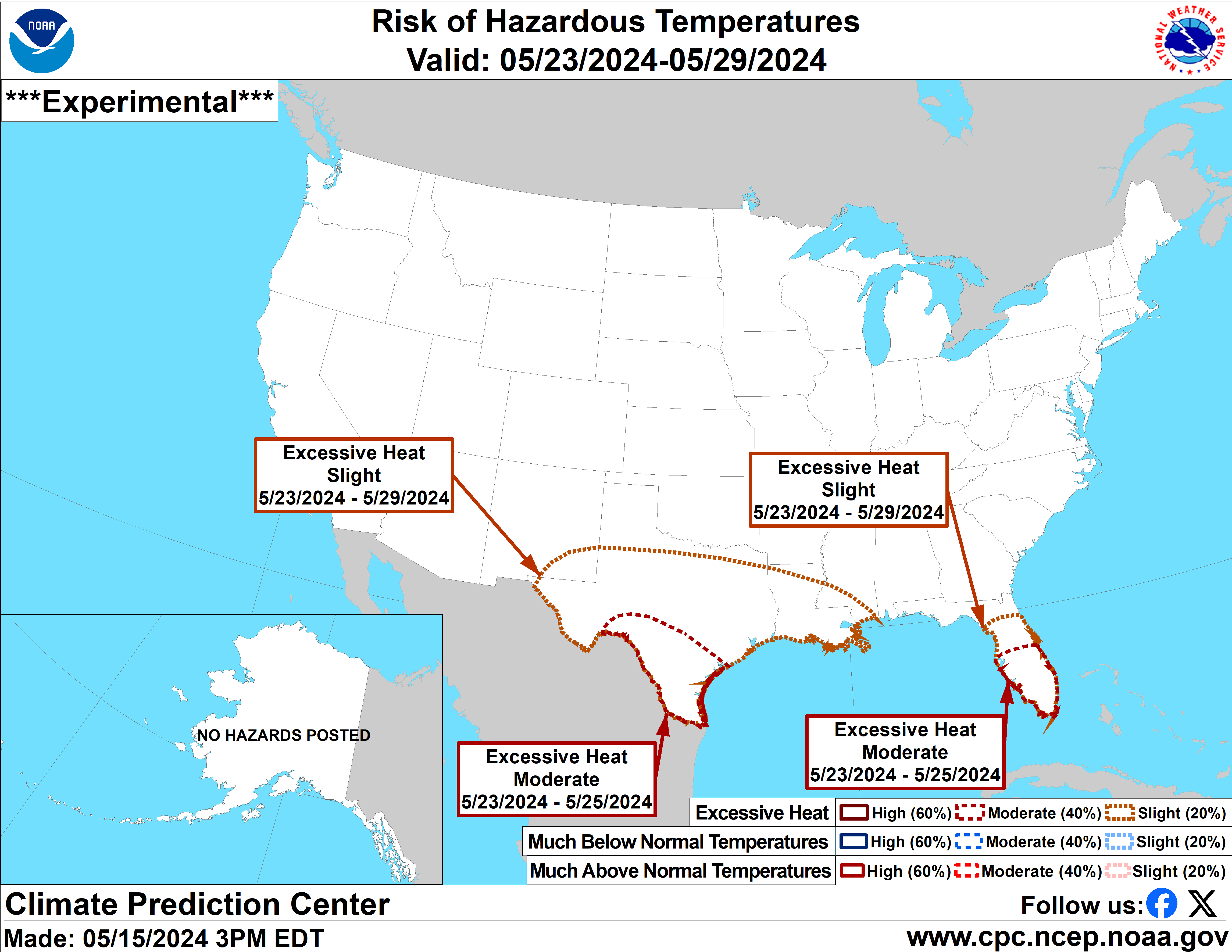
Excessive heat risk forecast (May 23-29, 2024)
Severe risk to increase for Central Plains, mid-Mississippi Valley, Corn Belt/Midwest, and Ohio Valley/lower Great Lakes (May 20-30 +)
A long-wave trough will take hold over the western third of the U.S. next week, a feature we watch closely during severe weather season. Over the next few days, severe weather will occur closer to the Gulf, but we’ll start to see a northward shift of the threat zone starting next week, similar to what happened earlier in May. While parts of the Southern Plains and northern parts of the Southeast/Mid-South will remain under a severe weather risk, the biggest risk should shift into the areas mentioned in this headline. There’ll probably be quite an expansive warm sector as a series of surface lows develop in the lee of the Colorado Rockies and trek northeastward. Unfortunately, this pattern will likely favor more tornadoes, straight-line wind gusts, and large hail. While we don’t know the specifics of each upcoming severe weather event, we do know that the pattern will probably support another window of unsettled weather.

Heavy precipitation risk forecast (May 23-29)
A cooling trend across the western third of the U.S. + Northern Plains (not including New Mexico) (May 20-28)
It may currently feel like summer is on the doorstep, but a rather stubborn large-scale trough will develop and persist over the western third of the U.S. next week or longer. This pattern will favor below-average to well-below-average temperatures, especially across the northwestern quadrant of the nation. A sequence of shortwaves will trek southeastward from the Gulf of Alaska, helping reinforce much colder temperatures across Idaho, Montana, and Wyoming, also spilling into the Northern Plains in waves. Late-season mountain snow accumulations will likely accompany these shortwaves in those states. Parts of Washington State and Oregon, especially across the Cascades, could also receive rain/mountain snow with each wave. Across the southwestern quadrant of the U.S., this period should bring rather benign/dry and sometimes unseasonably cooler weather conditions. We’ll have to monitor eastern Colorado for any surface low that develops and could pose a severe weather risk.

Probability of above/below average temperatures (forecast for May 23-29, 2024)
Good job. Thanks for the newsletter!
Welcome back!