

Weather Highlights (Oct. 14-20, 2024)
Coldest air of the season so far

Colder pattern across eastern two-thirds of U.S. (Oct. 14 - 18)
As we speak, a cold front is sweeping across the eastern two-thirds of the U.S. This front is associated with a mid-level low dropping southeastward across the Great Lakes region. Ahead of this feature, a surface low will develop and strengthen as it rotates into New England on Monday. Areas from the Great Lakes region to New England will have elevated rain chances through early week. Lake and mountain-enhanced precipitation chances may last for a day or so longer, with even some snow chances across the higher elevations of New England.
As the cold front pushes through the Gulf Coast and Florida peninsula in the Tuesday-Wednesday timeframe, a second shortwave will drop into the Midwest and Great Lakes region. This feature will reinforce an even colder air mass behind the front, amplify a broad trough over the eastern U.S., and give the eastern half of the nation a taste of late fall weather around mid-week. Associated with this push of colder air, a few snowflakes–the first of the season–cannot be ruled out Tuesday night into early Wednesday morning in the western North Carolina mountains above 4,000 feet. Accumulations are not expected.
As a cold and strong high pressure system builds behind the front by mid-week, it’ll be mostly dry and chilly through Friday. Patchy frost will be possible as far south as the Tennessee Valley and lower Appalachians/foothills.

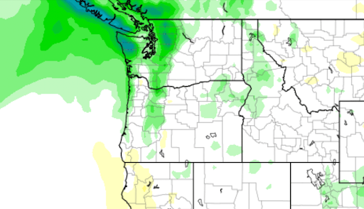
Seasonably unsettled pattern across Pacific Northwest through late week (Oct. 15 - 18)
A broad trough extending from parts of Alaska into the far northeast Pacific Ocean will establish an active pattern across the Pacific Northwest in the coming days. The first shortwave will approach the area starting on Tuesday before a second and stronger wave drops into the area later in the week. This pattern will increase snow chances across the Cascades around mid-week. By next weekend, the pattern will become a bit more zonal, potentially keeping precipitation chances more confined to western Washington state and British Columbia.
Colder/snowy pattern to emerge over western U.S. (Oct. 18 - 21)
Large-scale ridging for the first half of the week will keep the western third of the nation unseasonably warm. But a trough will begin moving across the West Coast on Tuesday and amplify as a strong shortwave drops into the Pacific Northwest. The model guidance disagrees on the overall strength of the wave and on the details of its track across the West. However, confidence is high that a colder, more active pattern will develop across much of the region by late week.
The evolution of the shortwave will determine if a rather large swath of the Rockies picks up snowfall late week into the weekend. The GFS model guidance depicts a stronger shortwave digging southeastward into parts of the Four Corners and then closing off into a mid-level low. This scenario would produce higher-elevation snowfall accumulations as far south as Utah, Nevada, and northern Arizona and bring snow levels much lower than what a weaker, faster-moving system would produce. Either way, probabilities are increasing that the coldest weather of the season is on its way by week’s end.

Great Plains rain/storm chances increase next weekend
Given the development of a large-scale trough across the western U.S. by late week, this will heighten the probability that surface low pressure will develop lee of the Rockies next weekend. Since the Plains will be coming out of a cooler, drier pattern, questions remain as to whether the air mass will have sufficient time to moisten to result in greater probabilities of severe weather across the lower and mid-Plains. Either way, rain/storm chances will increase across a rather large swath of the Great Plains next weekend.

As a "weather buff" I love getting Firsthand Weather's email. They are very detailed and interesting with great graphics too! THANK YOU!!!!
Thanks for the updates! You are always better than our local forecasters for sure. I enjoy the in-depth look at what is coming our way for the week. Keep up the wonderful, informative forecasts!