Weather Highlights (To Close The Month)
The false fall has ended; severe risk and more heat this week
A Newsletter Recommendation from Firsthand Weather
Weather with a Twist is a weekly(ish) email newsletter describing the latest research in meteorology with a lighthearted sense of humor. Published for free by the American Meteorological Society. Click to read the archive or subscribe.
Weather Highlights
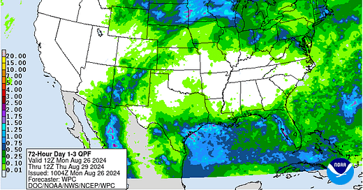
Stormy/rainy period for coastal Texas and coastal Louisiana
A strong ridge over the Plains will begin to move/expand eastward early in the week. A closed low trekking westward across the northern Gulf of Mexico will slide underneath the sprawling ridge and bring enhanced storm chances to much of the Texas coast and southwestern Louisiana coast. Even once the low passes, the region will remain positioned under deep, southeasterly flow from the Gulf and will generally remain favorable for stormy conditions for most of the week, including the Houston/Galveston area. It’s possible that a localized flooding risk will eventually develop after a few days of this pattern, especially in the urban areas.
Active/stormy pattern for Northern Plains, Upper-Midwest, and Upper Great Lakes area
Early in the week, the upper Plains and Upper-Midwest will find itself on the northern periphery of an expanding ridge. As a result, a large swath of the Midwest is under heat advisories or excessive heat warnings. Two strong shortwaves/closed lows will pass through these regions this week, which will bring at least two rounds of storms, potentially severe. The first wave will bring impacts early in the week and the second mid to late week. The air mass over these areas contains high moisture content, so flash flooding will be a concern as well. Both systems will usher in cold fronts, but the second wave later in the week will be responsible for ushering in noticeably cooler air into most of these areas by Friday.
Widespread heat wave across the Corn Belt, Ohio Valley, Mid-Atlantic, Tennessee Valley, and Southeast
A strong ridge, previously centered over the lower Plains, will move and build eastward by early week. As most expected, the cooler weather a few days ago was simply a false fall. All of these regions should expect temperatures to soar into the mid to upper 90s for much of this week. Quite a few places could reach 100. Even areas near the Ohio River and western West Virginia will really feel the heat, which will be heightened by the existence of severe drought conditions in those locations. Two cold fronts, associated with two northern stream systems that’ll trek across the northern Plains and Upper Midwest, should manage to make it to the Ohio River before stalling, especially the second one later in the week. This second front may bring some relief to parts of the Ohio Valley and upper Mid-Atlantic, but the ridge won’t begin moving out of the Southeast and lower Mid-Atlantic until late week. Most areas early to mid-week will experience very dry conditions and poor air quality. However, as the northern ridge periphery begins to flatten, the Ohio Valley and Mid-Atlantic will experience a heightened severe threat just after the week’s midpoint. By the weekend, storm chances will begin appearing in the forecast again across the Southeast and Tennessee Valley.
Wetter pattern (probably brief) in store for West Texas, eastern New Mexico, and western Oklahoma next weekend
This region has remained under the influence of a persistently strong ridge this summer. The combination of the big Texas heat and dry weather has exacerbated the severe to exceptional drought conditions. However, some relief may be on the way. The ridge will begin shifting eastward this week, placing the region on the western periphery of the ridge. A low pressure system will wrap around the ridge’s periphery later this week and a mid-level low could move into the Four Corners region this upcoming weekend. A few days of decent rain/storm chances, centered on the upcoming weekend, should bring some relief, though it won’t be a complete drought buster.
Active pattern across Florida peninsula
The Florida peninsula will most remain to the south/southeast to the ridge over the Southeast. Thus, residents, especially in the lower half of the peninsula, should expect the typical storminess each day. A more potent wave could reach the east coast of the state late week or this upcoming weekend, bringing more widespread storm activity. Also remember, we’re reaching peak hurricane season, and there’s no giant ridge in place to block any tropical mischief that decides to develop. Fortunately for now, the tropics are very quiet.


Love this ! Thank you
We need some rain here in East TN but it looks as if we will be waiting another week at least. Thanks for the update.